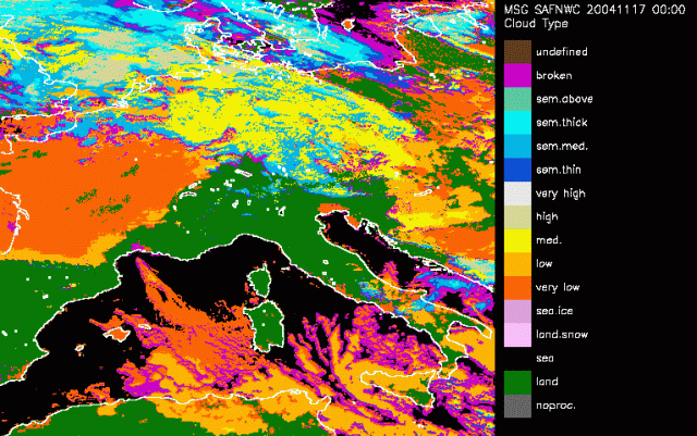
The CT classification algorithm is based on the following approach:
- Main cloud types are separable within two sets: the fractional and high semitransparent clouds, from the low/medium/high clouds. These two systems are distinguished using spectral features: IR10.8μm-IR12.0μm, NIR3.9μm-IR10.8μm (in night-time conditions only!), VIS0.6μm (in day-time conditions only!), and textural features (variance IR10.8μm coupled to variance VIS0.6μm in daytime conditions).
- Within the first set, the fractional and high semitransparent are separated using either their IR8.7μm-IR10.8μm brightness temperature differences, but also the VIS0.6μm visible reflectance (in daytime conditions only).
- The remaining categories are distinguished through the comparison of their IR10.8μm to NWP forecast temperatures at several pressure levels, IR10.8μm-WV7.3μm being used to make sure that low clouds are not wrongly classified as medium cloud in case strong low level thermal inversion.
- No separation between cumuliform and stratiform clouds is performed in the current version of CT.
At 18 November 18UTC the RaCy is clearly seen over Western Europe. We see the cloudhead over the North Sea, Netherlands and Denmark, which is diagnosed as high cloudiness. Down to the south the cold frontal part is diagnosed as semi thick clouds seen over France. In between is the dry intrusion, pictured here as medium to low clouds (further west), because of the deepening of the stratospheric air.
Another nine hours later at 19 November at 03UTC the remarkable second cyclogenesis is observed in the Cloud Types. A first PV anomaly is observed over Southern Germany, a second area of cyclogenesis is found just south of the Alps in the eastern part of Austria. Both these areas are diagnosed well by medium and low clouds. Another 3 hours later this separation of two areas of cyclogenesis is even better seen. The cloudhead of the RaCy is consistant of high clouds and the cold frontal part as semi thick cloudiness. At 09UTC the influence of the Alps is visible. High barrage clouds north of the Alps and further down south more lee clouds. The rol of the Alps on the cyclogenesis is also quetionable now. The two PV anomalies are still observed. A northern one over Poland and further south in Slovenia the second cyclogenesis. A discrimination that becomes even clearer at 12 UTC. The dry intrusion part of the PV anomalies is diagnosed as low to medium clouds separated by the Alps.