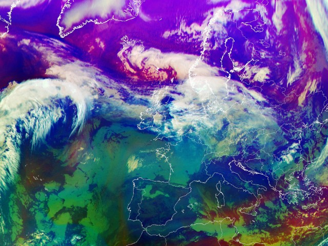


In this time sequence the Airmass RGB is used to investigate the role of stratospheric air in the development of this case study. It is also helpful to identify the position of the jet stream.
Note. You can always click on the  to bring up the RGB-key.
All features used in this RGB are strongly related to airmass characteristics in cloud-free areas and to cloud height in cloudy areas.
A special use of the Airmass RGB is the early detection of rapid cyclogenesis. The focus in the first images should therefore be laid on the area south of Greenland.
Features like the double structure of low upper tropospheric humidity as shown in WV images can also be revealed with the Airmass RGB. This structure appears in a dark blue colour.
The frontal zone is marked by high cloudiness. It clearly separates arctic airmasses in the North from subtropical airmasses in the South. The cold airmasses appear in blueish colours while the subtropical warm airmasses with a high tropopause show a greenish tone.
Cold airmasses are advected intensively to the South while warmer airmasses are advected to the North. This hints at the increasing temperature contrast and the frontogenetic development.
The upper air stream approaches the surface wave. The temperature contrast increases, leadin to less stable conditions. An elongated area of layered cloud lies along the flow poleward of the frontal cloud band. This pattern is frontogenetic rather than cyclogenetic at this time step.
The elongated area of layered cloud shows a convex poleward edge from this time on and can be regarded as a cloud head now. The separation from the cloud band by a dry tongue is starting.
Cold air indicated by blue colours is advected farther to the South. The system develops baroclinic conditions. The role of stratospheric air can be described by regarding the reddish areas which indicate downward-protruding dry air from the lower stratosphere. This development should be paid attention to in the next images.
The reddish area of stratospheric air rapidly moves to the South. It clearly coincides with the position of the dry intrusion.
The advection of the dry upper stream into the area of cloudiness leads to the dissolution of clouds. Note the sharp transition from blue to reddish tones. The jet stream can be located in this transition zone. Cirrus cloudiness represented by narrow cloud fibres also indicates the position of the jet.
The dissolution of cloudiness can be further observed strongly associated with cold stratospheric air.
Two red areas indicate the development of two decoupled processes. One red area is connected to the area of cloud dissolution at the upper front to the South. The other red area is found southwest of the cloud head where dry air intrudes in the next time steps. This is the relevant location for the rapid cyclogenesis.
The cold front reaches central Germany. The upper front is situated far to the South. The area of cloud dissolution extends to the sharp edge of the upper front. The Airmass RGB reveals two areas of cyclogenesis.
The formation of a narrow dry slot between the cloud head and the surface cold front can clearly be seen. The dry slot is filled with stratospheric air.
The existence of stratospheric air in the dry slot is most clear in this RGB image. Note also the wide area of enhanced cumuli and cellular cloudiness in the cold air behind the front.
The influence of stratospheric air can still be observed. Usually these areas coincide with a PV-Anomaly indicating a lowering of the tropopause (see chapter: Potential Vorticity).
Deep red areas are seen in the dry air within the cloud head as well as on the rearward side of the front. The area of stratospheric air now expands to the lee side of the Alps.
The further flow of stratospheric air and the development of a huge cloud spiral can be followed in these last images.
The further flow of stratospheric air and the development of a huge cloud spiral can be followed in these last images.
The further flow of stratospheric air and the development of a huge cloud spiral can be followed in these last images.
The further flow of stratospheric air and the development of a huge cloud spiral can be followed in these last images.
The further flow of stratospheric air and the development of a huge cloud spiral can be followed in these last images.
The further flow of stratospheric air and the development of a huge cloud spiral can be followed in these last images.
The further flow of stratospheric air and the development of a huge cloud spiral can be followed in these last images.
The further flow of stratospheric air and the development of a huge cloud spiral can be followed in these last images.
The further flow of stratospheric air and the development of a huge cloud spiral can be followed in these last images.
The further flow of stratospheric air and the development of a huge cloud spiral can be followed in these last images.
The further flow of stratospheric air and the development of a huge cloud spiral can be followed in these last images.
The further flow of stratospheric air and the development of a huge cloud spiral can be followed in these last images.
The further flow of stratospheric air and the development of a huge cloud spiral can be followed in these last images.